Towering heights of the Kunlun, a huge mountain range bordering the Tibetan Plateau from the North, have down to present days remained a “blind spot” on the maps, where only very few paths have been made by very few travellers. One of the first of those, Nikolai Przhevalsky, gave Russian names to ridges and peaks in Kunlun. Major discoveries are still possible and are still made in this region even today, although it might seem that the “eyes” of observation satellites have penetrated everywhere. In 2009 the expedition lead by Otto Chkhetiani discovered a new summit, Eastern Chong-Muztag (6976 m), in the upper course of the Keriya river. A highest peak in the range that wasn’t mapped nor catched on satellite images.
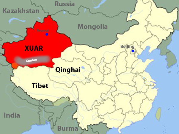
 Map of China. The red area highlights Xinjiang Uyghur Autonomous Region (XUAR) of China, where the expedition took place. XUAR borders Tibet to the South, Quinghai and Gansu provinces of China to the East. Capital of XUAR is Urumqi. Along the southern border of Xinjiang stretch from the West to the East the ranges of Kunlun mountains.
From the glaciers of Kunlun, copious rivers break through the mountains on their way to Taklamakan desert, where they vanish in the immense sands. We know of only two attempts to descend these rivers. In 1990 an American team succeeded in conquering the middle and low course of the Yarkand River, the westernmost river in Kunlun. In 2007 a Russian expedition team lead by Sergey Chernik made the first descent of the upper course of the Yurunkash river, but ended by death of four members of the team on one of the most difficult stretches of the river.
 Most distinguished travellers of the past and of the present drooled over this part of China. Center of the map is covered by the great Taklamakan desert, still hiding cities of lost civilizations under its sands. A “swamp” to the right – Lopnur lake bed, that served the main drainage for the rivers of the whole of Central Asia. Its shores were seen by Hedin and Przhevalsky, the most famous Chinese traveller, Yu Chunshun, died of dehydration here in his attempt to cross the Lopnur lake in 1986. Roads, crossing the south border of XUAR, are the legendary Karakoram and Western Tibet Highways, highest roads in the world. Little red triangles between them – are in fact huge and beautiful mountains: Muztagh Ata, Kongur, K2 (Chogori). This is the “background” for our rivers – and they really do deserve such magnificent settings.
Our goal was to make the descend of a river to the east of the Yurunkash – either Keriya or Cherchen. Present situation in XUAR is not stable – Yugurs don’t accept willingly the policy, applied to their people by the official Beijing. Foreigners tend to be kept away from the mountains and are intimidated by the potential encounters with insurgents and terrorists. We stilll were lucky to get to the Cherchen river and to make the first descent of the whole of its raftable section. Our descent started in the mountains and ended among the sand dunes of Taklamakan.
The Cherchen turned out to be an increadible river, it is all clamped in narrow canyons with exits, that could be counted on fingers. Sometimes we had to scout downstream sections virtually, using only satellite images. Sometimes even the images could not help – meandering walls of the canyon overlaid the river course, hiding it from the satellite. We called such sections “Subway” and were on the alert, frightened by the Cherchen, squeezing through narrow passages. But we still moved forward.
Start and finish of the descent shown on the interactive map – Put-in and Take-out point. Also shown – point of entering the “Escalator Crevice” and point of entering the first Subway tunnel. Try to find the other Subway tunnels on the map – from the second to the sixth.


